

SkyrimNoob101
New Member
I'm new to this game series. But I was watching a youtube video and wanted to find out how much of this is true or what the game has to say about it.
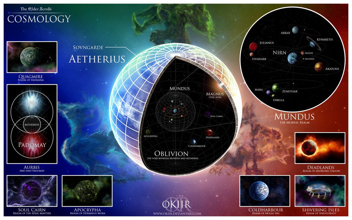
But by the looks of the globe of skyrim I'm assuming this is earth after mars became a moon or it assumes we live after mars left as a moon and this is prehistory. I'm assuming the game is possibly after it joined unless the earth kept it's shape for a long time and this game is the future.
If you compare the world to a modern globe/google earth you will find:
1. High rock look like norway region of modern Europe.
2. Hammerfell looks like eastern europe/russia just below this and the rest of euorope appears to be under the sea.(possibly explained by the large mars like moon being there.
3. Summerset Isle looks like egypt split by a very full nile river. Or the arabian area where the mountains are. EI the red sea an it's large mountains.
4. Pyandonta is either ethiopia or the arab emerates.
5. Yokuda is possbly great britain combined with mountains in france/spain.
6. Valenwood appears to be iran with all of it's mountains and the lower lands including india south of the himalayias all sank.
7. Argonia is possibly the mountains of china and the norther himilayias. the islands are possibly Korea and japans mountain areas.
Edit: Optionally: If corinth is corinth in greece then it's simpler to figure out. Impieral capital my just be athens or a greek city.
The rest appears to be underwater.
It looks like all the areas correspond to large mountains on google earth.
If you follow the spacing the rest of the globe looke like either greenland or parts of great britain above the water. I dont know if this all makes sense with the current height of land, but if mars became a moon it could have adjust the earths crust and potentially made some land rise etc.
There was also a continent that looked a bit lie parts of canada to the north and some of the US. Can't find a good pic though.
Does the game give hints or explain what the land is compared to modern earth? Because visually it appears to be made from our actual globe to some extent.
Here is a map. Kamal looks like norther canada and the hudson bay area.
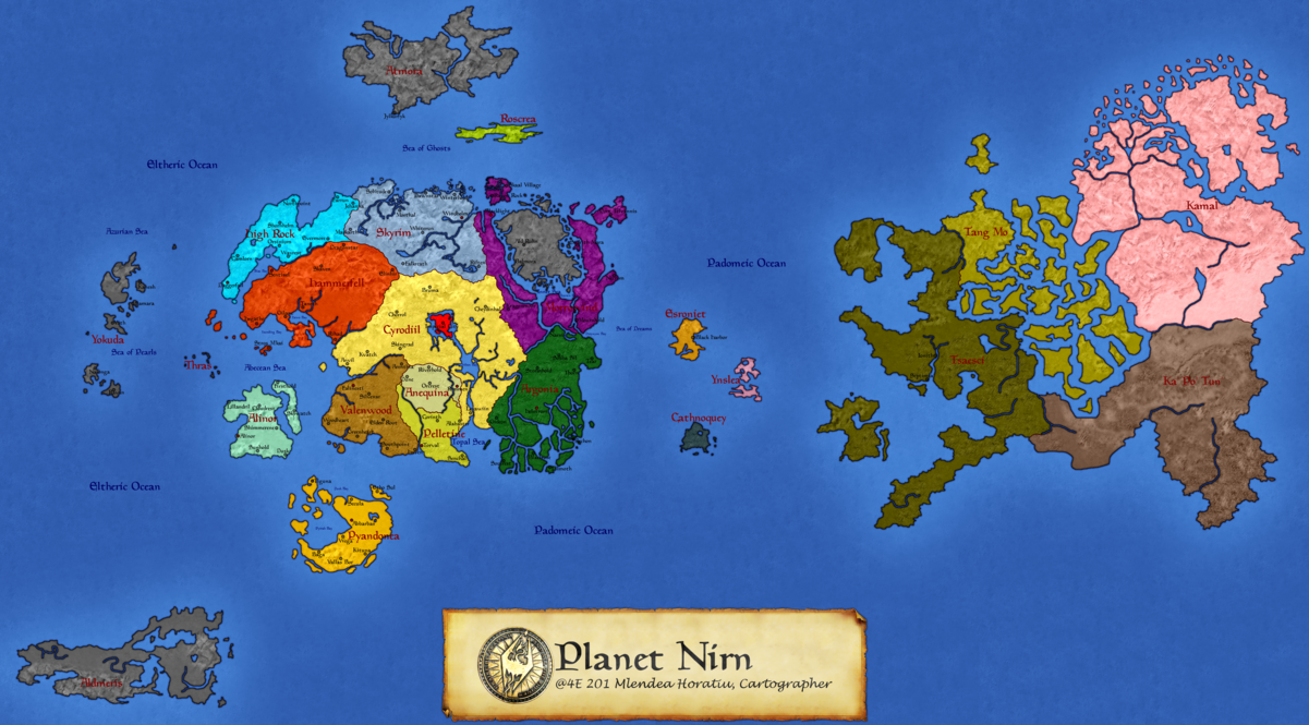
Real earth:

But by the looks of the globe of skyrim I'm assuming this is earth after mars became a moon or it assumes we live after mars left as a moon and this is prehistory. I'm assuming the game is possibly after it joined unless the earth kept it's shape for a long time and this game is the future.
If you compare the world to a modern globe/google earth you will find:
1. High rock look like norway region of modern Europe.
2. Hammerfell looks like eastern europe/russia just below this and the rest of euorope appears to be under the sea.(possibly explained by the large mars like moon being there.
3. Summerset Isle looks like egypt split by a very full nile river. Or the arabian area where the mountains are. EI the red sea an it's large mountains.
4. Pyandonta is either ethiopia or the arab emerates.
5. Yokuda is possbly great britain combined with mountains in france/spain.
6. Valenwood appears to be iran with all of it's mountains and the lower lands including india south of the himalayias all sank.
7. Argonia is possibly the mountains of china and the norther himilayias. the islands are possibly Korea and japans mountain areas.
Edit: Optionally: If corinth is corinth in greece then it's simpler to figure out. Impieral capital my just be athens or a greek city.
The rest appears to be underwater.
It looks like all the areas correspond to large mountains on google earth.
If you follow the spacing the rest of the globe looke like either greenland or parts of great britain above the water. I dont know if this all makes sense with the current height of land, but if mars became a moon it could have adjust the earths crust and potentially made some land rise etc.
There was also a continent that looked a bit lie parts of canada to the north and some of the US. Can't find a good pic though.
Does the game give hints or explain what the land is compared to modern earth? Because visually it appears to be made from our actual globe to some extent.
Here is a map. Kamal looks like norther canada and the hudson bay area.
Real earth:
Last edited: